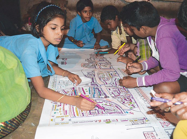
Children from Hyderabad and Bhubaneswar are putting their ‘invisible’ slums on maps, forcing urban development authorities to provide amenities
Have you ever tried to search for your home on Google Map? Chances are that you have. But have you tried looking up slums? They appear blurry and are often clumsily outlined. Maps often literally, and in more ways than one, make slums invisible and by default undiscoverable and unnavigable. Such deliberate sidelining of slums, an informal yet important socio-economic engine of urban life, not only does a great dis-service to the people living there, but also keeps away essential governance services, civic amenities and rights from them.
Rajesh Das, a 14-year-old resident of OUAT Farmgate basti in the Odisha capital Bhubaneswar, is one of many children who do not want their slums to be invisible and fuzzy to the outside world anymore. Rajesh and his friends, along with the non-governmental organisation (NGO) Humara Bachpan, are trying to present a clear picture of their forgotten slum to the authorities.
Armed with colour pens and crayons, the children have created maps of their slum giving visibility to their homes. Through colourful Venn
diagrams, dots and sketches the children have mapped several indicators like number of families, total population, households with toilets, families living in kutcha houses, open spaces, dumping yards and exposed drains in the slum, among other things. As a result of these efforts, their slum is no longer an empty space on government maps. “The rationale behind involving children in urban planning and mapping of their neighbourhood was to bring forth child participation in designing cities where they grow up,” explained Preeti Prada, national head of Humara Bachpan Campaign.
Not stopping here, the children further developed a ‘dream map’ of their slum, whereby they highlighted facilities which they want. Giving a new perspective, the children revealed several issues which were often ignored by adults. “I want open drains to be properly covered in my area. When they overflow, flies hover on them and spread disease and infection,” said Rajesh. He also highlighted the need of toilets in his dream map. “I want toilets for individual houses in the basti, so that we don’t have to go to anganwadi every time, to relieve ourselves.”
“Children understand their issues better than adults, and can come up with their indicators in terms of a safer and healthier neighbourhood and city,” added Prada. The dream map highlighted things like lack of proper schools, dark areas without streetlights, garbage littered, uncovered manholes, hanging electricity wires, lack of individual toilets, more drinking water facilities in anganwadi, no barricade around the transformer and lack of a playground. Another child, Shradhanjali Panda from the Farmgate basti, said, “I want pucca roads in our slum area, which has a provision for zebra crossing. I also want trees in my basti.”
Agents of change
A similar initiative was held in around 20 urban slums of Hyderabad. Here, children brought forth several issues like small and congested houses, lack of separate rooms for children, playgrounds and clean drinking water. “The children were able to identify issues, analyse the root problem and come up with ideas and solutions to resolve these issues,” said A Venkateshwarlu, project manager of Bala Raksha Divya Disha which facilitated the mapping programme in Hyderabad. For instance, during the mapping exercise in Basavataraka, slum children presented some solutions to the problems which the officials from Greater Hyderabad municipal corporation (GHMC) were unable to resolve.
“The GHMC officials had refused to lay the concrete roads in the bylanes of the slum saying it was not possible due to the drainage system. The children, with support from their mothers, had come up with the idea to lay the concrete road without damaging the drainage system and succeeded in getting the road laid,” explained Venkateshwarlu.
Out of the shadows
Taking matters of urban development in their little hands, children from the slums of Bhubaneswar gave their maps to the mayor of the city. “Mayor Sir has promised us that he will improve our condition and will realise our dreams,” said Rajesh. The mayor, Ananta Narayan Jena, meanwhile, has initiated a slum project plan to meet the requirements highlighted by the children.
“The project will take some time, but we have started working in this direction,” Jena told Governance Now. Moreover, the mayor also said an extensive GIS mapping of the city has been done. “Apart from mapping the slums of the city, drainage systems, roads and population have also been mapped,” he said.
Perhaps, now the government might consider linking the maps prepared by the children with the GIS database of Bhubaneswar to give a better representation to the Farmgate basti.
Odisha state housing board chairman Pratap Keshari Deb said with the technological support of IIT Kharagpur, the entire city of Bhubaneswar, including slums, had been mapped. “A future perspective plan has been finalised for another 25 years on the basis of these maps,” he added. The mapping efforts have further helped identify encroached government land. This can be seen as a next step whereby the government can make plans to provide sanitation and other amenities and rehabilitate slumdwellers. Realising the significance of technology, the NGO is planning to use GIS maps developed by Bernard van Leer Foundation and Coleague Solutions for its future projects.
ridhima@governancenow.com

